Hiking Mount Rinjani is the kind of adventure that sounds romantic when you first read about it online. A multi‑day trek across an active volcano in Indonesia? Watching the sunrise from nearly four thousand meters above sea level? Camping on the rim of a massive volcanic crater? It all sounds incredible.
And it is.
But let’s be honest, hiking Mount Rinjani is hard. Brutally hard in places. Especially for the casual hiker. The climb is steep, the terrain constantly shifts beneath your feet, the summit push starts in the middle of the night, and there will almost certainly be moments when you question every life decision that led you to the side of a volcano at 2 a.m.
Yet that’s exactly what makes it so special.
Standing on the summit of Mount Rinjani as the sun rises over Lombok is one of the most unforgettable travel experiences in Southeast Asia. In that moment, exhausted, freezing, and grinning like an idiot, you will realise the suffering was part of the magic.
This guide will walk you through everything you need to know about hiking Mount Rinjani: how to book your trek, what the trail is actually like, what to expect during the infamous summit push, and whether the experience is really worth it.
Spoiler: it absolutely is.
What is Mount Rinjani?
Mount Rinjani is an active volcano located on the island of Lombok in Indonesia. At 3,726 meters (12,224 feet), it is the country’s second-highest volcano and one of Southeast Asia’s most spectacular trekking destinations.
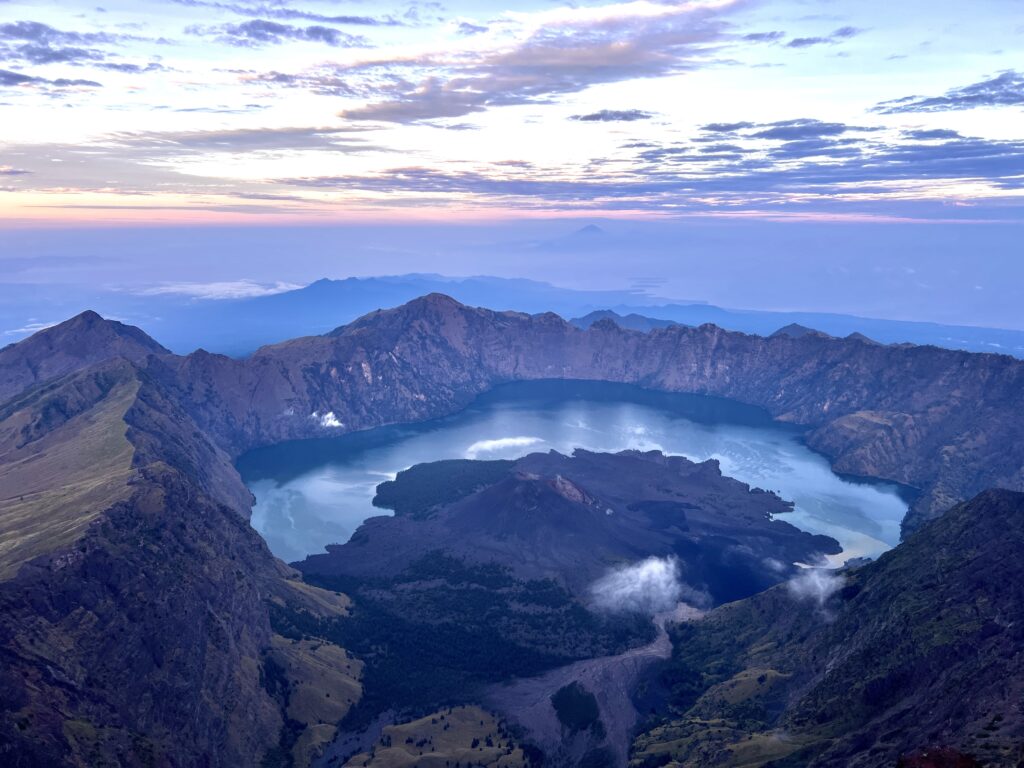
Inside the massive caldera sits Segara Anak, a stunning turquoise crater lake surrounded by volcanic cliffs. Rising from the lake is an even smaller active cone, Mount Barujari, which occasionally erupts and reminds visitors that this mountain is very much alive.
Hiking Mount Rinjani is not just about reaching the summit. The trek combines multiple landscapes: grassy savannahs, dense forests, volcanic ridges, alpine woodlands, and dramatic crater views. Few hikes pack this much variety into just two or three days.
Where is Mount Rinjani?
Mount Rinjani is located in Rinjani National Park in the north of the Indonesian island of Lombok (just east of Bali).
What to expect from the hike?
Incredible Views
The views on Mount Rinjani are absolutely world-class.
Throughout the hike, you’ll pass through wide-open savannah, dense forests, misty cloud zones, and eventually the dramatic volcanic ridges that surround the massive crater lake Segara Anak.
But the real highlight is reaching the crater rim.
After hours of sweating your way up the mountain, you suddenly arrive at the edge of a gigantic volcanic caldera with clouds spilling over the rim and the turquoise lake far below. It’s the kind of view that makes you forget your aching legs,.. at least for a few minutes.
And then, of course, there’s the summit sunrise.
Standing at 3,726 metres on the summit of Mount Rinjani, watching the sun rise over Lombok and the surrounding islands, is one of the most unforgettable moments in Indonesia.
Constantly Changing Terrain
One of the most surprising parts of hiking Mount Rinjani is how quickly the landscape changes.
In the space of a single day, you’ll hike through:
- grassy savannah hills
- humid forest trails
- rocky mountain paths
- alpine woodland
- loose volcanic scree
Very Early Mornings
If you’re hiking Mount Rinjani for the summit, you’ll be waking up early.
Most summit attempts start around 2:00 AM, which means alarms going off around 1:30 AM in a cold tent on the crater rim.
Unpredictable Mountain Weather
Mount Rinjani has its own weather system.
Expect everything from sweating in tropical heat to shivering in bone-chilling winds within the same 24 hours.
Down in the savannah sections, the heat can be intense, with very little shade and high humidity. Higher up the mountain, the temperature drops quickly, and the wind can become surprisingly strong.
Clouds frequently roll across the slopes, sometimes reducing visibility to just a few metres before suddenly clearing again.
By the time you reach the crater rim, you will need warm layers, especially during the night and the early-morning summit climb.
Rustic toilets
This part of the experience might not surprise seasoned backpackers or hikers, but it’s worth mentioning.
There are very few proper toilet facilities on Mount Rinjani.
Most trekking companies set up simple latrines near the campsites on Sembalun and Senaru crater rims, and there are resonably well maintained squat toilets at POS 2 station for (10K IDR). However, during the hike itself, nature is very much your bathroom.
It’s not glamorous, but it’s part of the adventure.
Picking a Tour Guide & Booking the Hike
You cannot hike Mount Rinjani independently.
The trek is tightly regulated inside Rinjani National Park, and all hikers must join a licensed guided tour. This system ensures the safety of hikers, maintains the environment, and provides a much-needed income for the local population.
However, not all tour companies are created equal.
The differences can be significant: the experience of the guides, their ability to communicate in English, the quality of camping equipment, and even the number and fitness of the porters carrying supplies. When you’re spending two days hiking Mount Rinjani, those details matter far more than you might expect.
After far too many hours of comparing reviews and recommendations, I chose Rinjani Heroes. They had strong, solid feedback online and, crucially, seemed to run a well-organised operation. That decision paid off almost immediately.
By the time we staggered up to the crater rim after hours of climbing, our camp was already set up, tent pitched, sleeping mats ready, and even a few tables and chairs positioned perfectly to look out across the enormous volcanic caldera. After a long day of hiking Mount Rinjani, collapsing into a ready-made campsite felt like five-star luxury.
After a long day of hiking Mount Rinjani, collapsing into a ready-made campsite felt like absolute luxury.
The food was also surprisingly good, which becomes extremely important when you’ve been climbing a volcano all day. Hot meals, decent sleeping bags, and solid tents might sound like small details when you’re booking the trek, but trust me, you’ll appreciate every single one of them once you’re halfway up the mountain.
Where does the hike start?
The starting point for each hike varies depending on the route and tour guide used. Most hikes start their trek from one of two villages Sembalun or Senaru.
- Sembalun Village Gate – the main starting point for summit treks
- Senaru Village Gate – often used for crater rim or longer trekking routes
- Timbanuh Village Gate
- Aik Berik Village Gate
- Torean Gate
The most popular itinerary for hiking Mount Rinjani is the two-day, one-night trek via the Sembalun route. This route allows hikers to reach the crater rim on day one, summit the volcano at sunrise on day two, and descend the same day.
My experience Hiking Mount Rinjani: A Day-by-Day overview of the 2 Day 1 Night hike
Without further ado, let’s discuss the day-to-day experience of what hiking up Mount Rinjani actually looks like.
I opted for the 2 days, 1 night Sembalun route. This covers a hike to the Sembalun crater rim, where you camp over night, then a hike to the summit of Rinjani before heading back down to the starting point. Here is a breakdown of my experience during the hike, the good, the bad and the incredible.
Day 1: Hiking Mount Rinjani to the Sembalun Crater Rim
Sembalun Village (1,156m) → Sembalun Crater Rim (2,639m)
Day one of hiking Mount Rinjani started in the quiet mountain village of Sembalun, tucked beneath the enormous eastern slopes of the volcano. From down here, the summit was hidden behind a blanket of clouds, which was probably a good thing; if I could have seen the full climb waiting above, I might have reconsidered the entire plan.
Our morning began at the Rinjani Information Centre (RIC) in Sembalun Lawang, the official check-in point for anyone attempting the trek. This is where every group registers before heading onto the mountain. Permits are checked, identification is logged, and basic health declarations are completed so that park authorities know exactly who is up there.
Thankfully, our guides handled almost all of it.
While we stood around trying to wake up properly, they sorted the permits, paid the entrance fees for Rinjani National Park, and navigated the paperwork like seasoned professionals. All we needed to do was scribble our names onto a few forms and show our passports.
It’s a small administrative step, but it also makes the whole thing feel suddenly real.
Once you sign that register, you’re committed.
You are officially hiking Mount Rinjani.
What are POS Checkpoints?
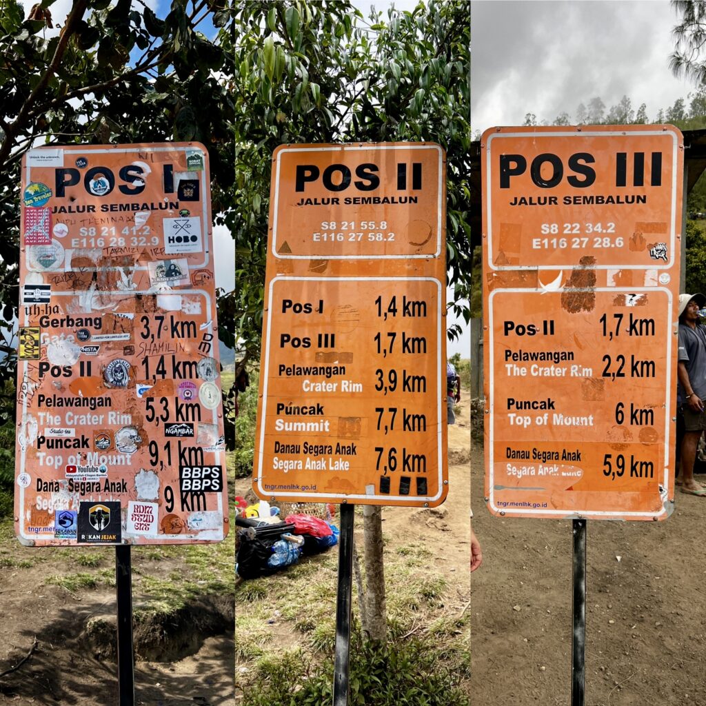
The Sembalun route is divided into several checkpoints called POS stations, short for “post” or “station” in Indonesian.
These stops act as rest points, navigation markers, and psychological milestones along the trail. When you’re slowly grinding your way up a volcano for hours, the promise of the next POS becomes an incredibly powerful motivational tool.
Each one marks a different stage of the climb as the terrain gradually changes from savannah grasslands to exposed volcanic slopes.
Trust me, when you’re hiking Mount Rinjani, every checkpoint feels like a victory.
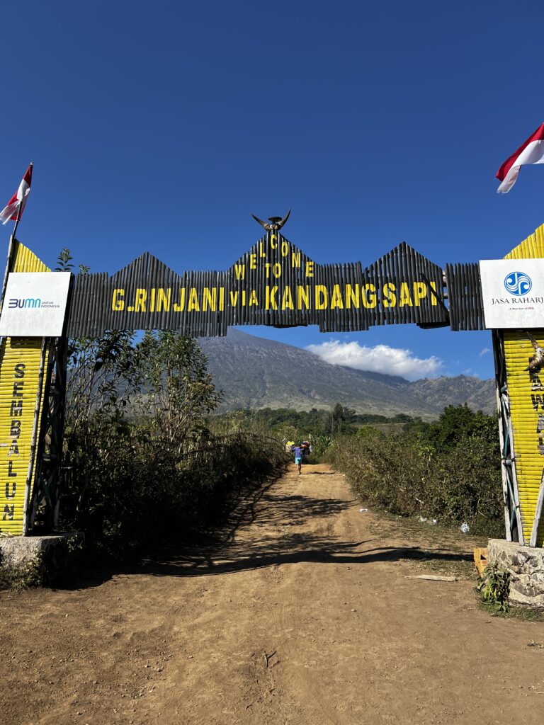
Entrance Gate to POS 1 – 3.9 km
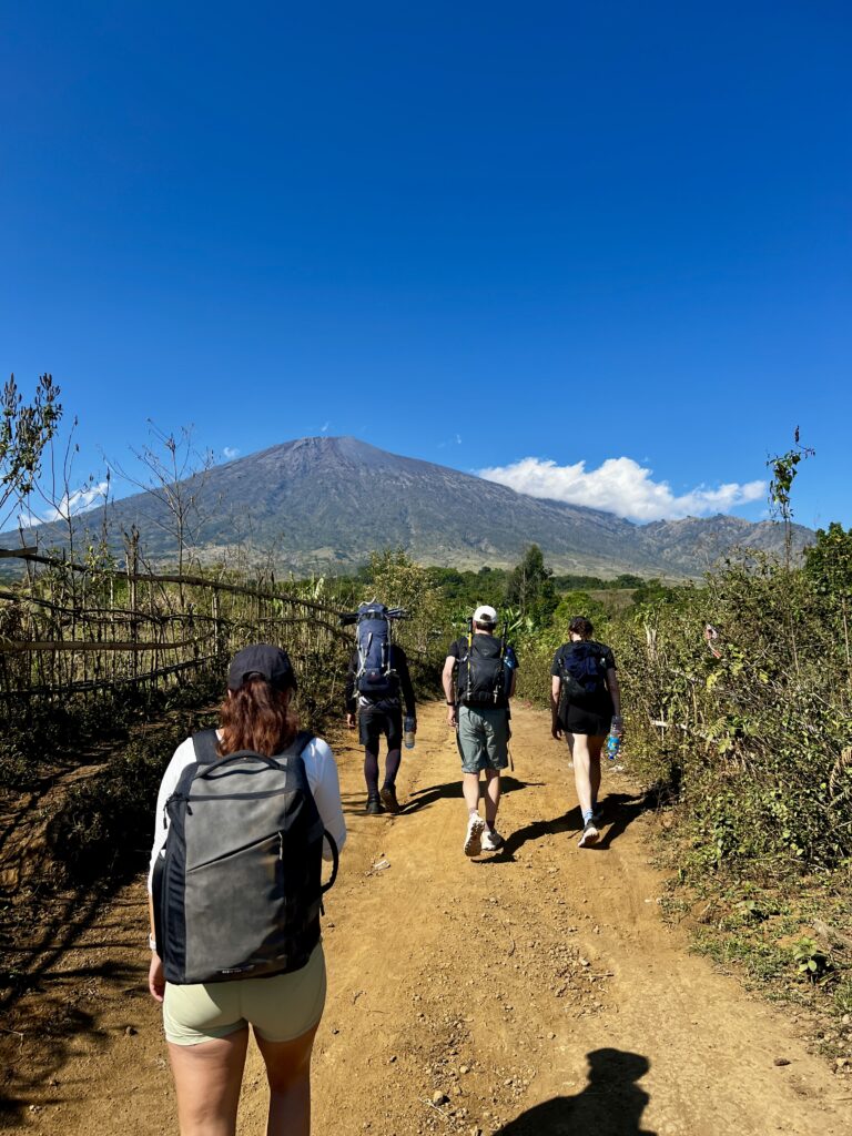
By 8:30am, we were standing beneath the large wooden entrance gate that marks the beginning of the Sembalun route. Backpacks adjusted, water bottles filled, sunscreen applied like our lives depended on it.
The first section of the trail feels almost suspiciously easy. A wide dirt path winds gently uphill through open savannah, surrounded by rolling hills and grazing cows that look mildly confused about why a line of sweaty tourists is marching through their pasture.
The first section of the trail stretches roughly 3.9 kilometres to POS 1.
The ground is dry and dusty. The path is well-worn. And the views stretch endlessly across the Lombok countryside.
For the first hour or so, hiking Mount Rinjani feels more like a countryside stroll than a serious volcano trek.
This is the mountain luring you into a false sense of security.
POS 1 to POS 2 – 1.4 km
The next stretch between POS 1 and POS 2 is shorter (roughly 1.4 kilometres), but the terrain begins to change.
The gentle hills become steeper. The trail narrows slightly. Embedded rocks and boulders start appearing beneath your feet.
This is where the hike shifts from casual walking to steady uphill effort. The cows disappear, replaced by scrubby vegetation and occasional clusters of trees that provide brief but welcome shade.
The climb isn’t technical, but it’s relentless. The path winds across steep grassy slopes, climbing higher and becoming steeper, with flat sections confined to the tops of the rolling hills.
By the time we reached POS 2, the group was noticeably quieter.
The mountain had begun to take its toll.
Lunch at POS 2
POS 2 sits roughly halfway up the climb to the crater rim and serves as the official lunch stop for most trekking groups.
By the time we arrived, our porters had already beaten us up the mountain and somehow transformed a small clearing into a makeshift mountain café.
Lunch consisted of Mie Goreng, vegetables, tofu, tempeh, crackers, and fresh fruit, with optional chicken, which felt absurdly luxurious given we were halfway up a volcano.
While we ate, a group of monkeys gathered nearby and began staging what can only be described as a chaotic and violent soap opera.
They fought over food scraps, chased each other through the trees, and occasionally made aggressive attempts to steal unattended snacks from unsuspecting hikers.
It was equal parts entertainment and security reminder. Remember, never leave your food unattended around monkeys.
They will absolutely win that fight.
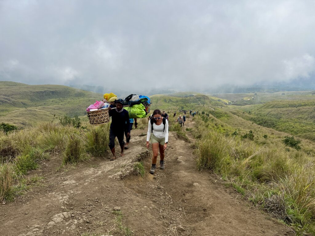
Porters
Porters pass us along the trail carrying what appears to be the entire contents of a small restaurant on their backs — food supplies, tents, chairs, tables, gas stoves — all balanced on bamboo poles while they casually stroll uphill in flip-flops.
Watching them move makes you realise two things very quickly:
- They are absolute legends.
- Your own fitness suddenly feels very questionable.
POS 2 to POS 3 – 1.7 km

The trail between POS 2 and POS 3 climbs roughly 1.7 kilometres, but the terrain becomes significantly steeper and more rugged.
Large boulders begin to litter the path. Sections of gravel appear, and the forest thickens before slowly thinning again as you gain altitude.
The climb is constant.
Step after step after step. Your quads will begin to hurt here.
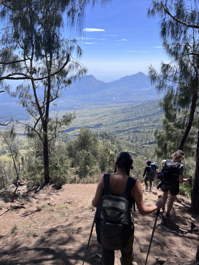
The higher we climbed, the more dramatic the environment became. Clouds drifted across the mountainside, sometimes swallowing the trail in mist before clearing again to reveal sweeping views across Lombok.
Temperature, humidity, and visibility shifted almost hourly.
And yet, despite the effort, there was something surreal about realising you were hiking Mount Rinjani, one of Indonesia’s most iconic volcanoes, while clouds rolled across the slopes beneath your feet.
Yes, it was hard work.
But it was also pretty damn cool.
POS 3 to The Crater Rim – 2.2 km
The final stretch to the crater rim is where the landscape becomes distinctly volcanic.
Twisted Casuarina trees, which dominate the upper slopes of Mount Rinjani. These are pine-like trees that grow in dense clusters, often with gnarly branches swaying in the wind and creating a quiet, almost eerie atmosphere.
The sound that the wind makes whistling through the Casuarina is mesmerising. At this altitude, the clouds are below you, making the views spectacular, for the less fit you will have plenty of time to enjoy these views while stopping for breath.
The climb here is steep.
Very steep.
Large volcanic rocks and loose gravel cover sections of the trail, making every step feel heavier than the last. On the way up it’s tiring. On the way down, you will find it… interesting.
But at this altitude, something magical happens.
The clouds drop below you.
Suddenly, the island spreads out beneath the mountain, with sweeping views across Lombok and distant coastlines fading into the horizon.
You will have plenty of time to enjoy these views while stopping, gasping for breath.
Reaching the Crater Rim
After roughly six hours of hiking Mount Rinjani, the trail finally levels out.
And then the landscape explodes open.
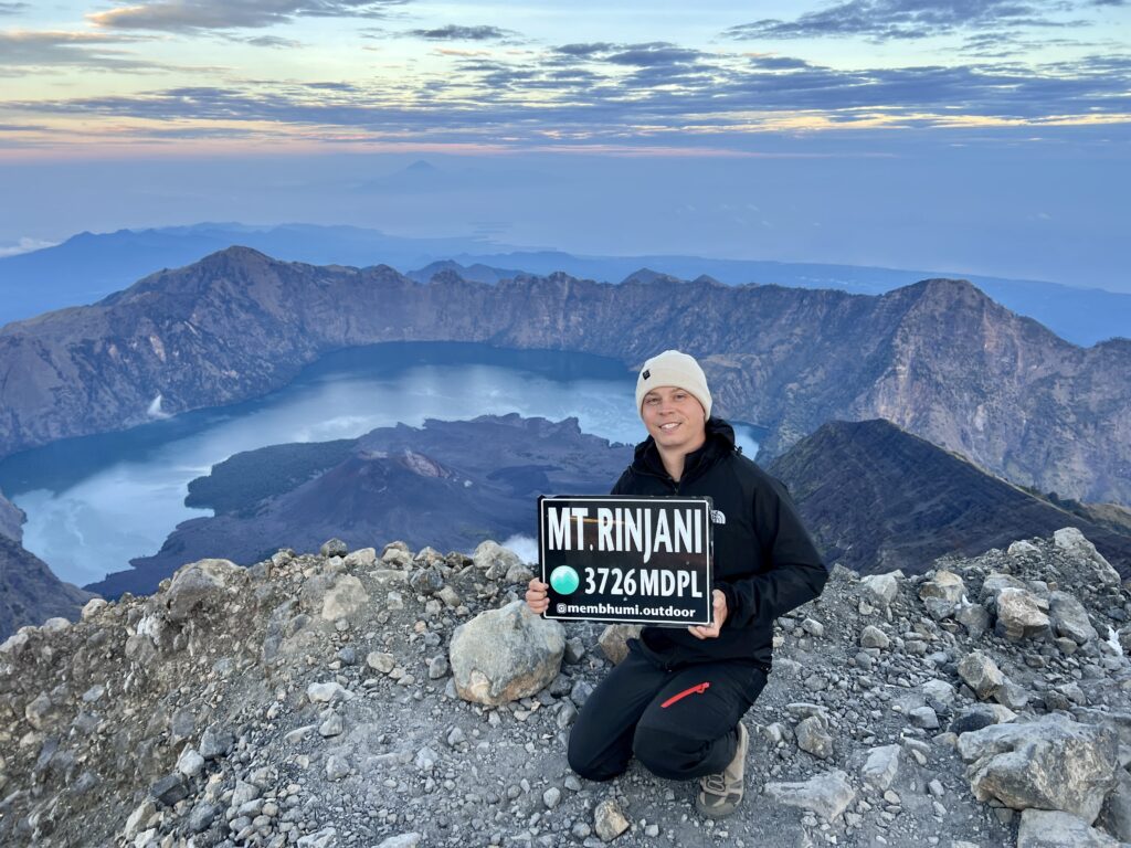
Standing on the Sembalun Crater Rim (2,639m) for the first time is a moment I’ll never forget.
The enormous volcanic caldera stretches out below you like a giant collapsed bowl, revealing the deep blue waters of Segara Anak Lake far beneath the cliffs.
Clouds spill over the rim and cascade down toward the lake.
Near the centre of the lake, the smaller volcanic cone of Mount Barujari quietly steams inside the crater.
It’s one of the most spectacular views in Indonesia.
And after six hours of climbing, it feels incredibly well earned.
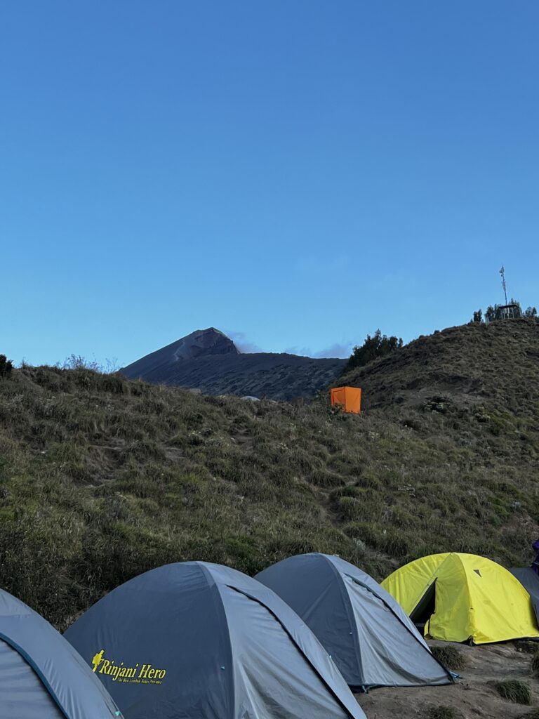
Camp Life on the Crater Rim
When we arrived at camp, our porters had already set everything up.
Tents were pitched. Sleeping mats were laid out. Chairs and tables faced the view across the caldera.
After a full day hiking Mount Rinjani, it felt like arriving at a five-star hotel — if that hotel happened to be perched on the edge of an active volcano.
The first thing I did was kick off my boots, crawl into the tent, and fall asleep for 45 minutes.
No ceremony.
Just pure exhaustion.
Later that evening we watched the sunset spill across the crater rim while clouds drifted down toward the lake. Dinner was served as the sky turned deep orange and red.
A cold Bintang beer appeared from somewhere.
It was one of those travel moments you wish you could freeze in time.
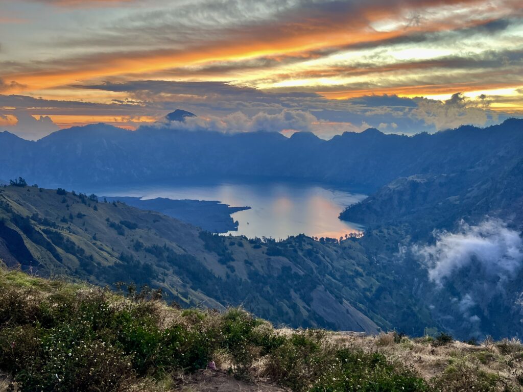
The stunning sunset view from the Sembalun Crater Rim campsite of Segara Anak lake, inside the caldera of Mount Rinjani, Lombok, Indonesia.
The Less Glamorous Reality
Of course, crater rim camping also comes with a few… realities.
Monkeys and rats roam the campsites in search of food. Trekking groups have used some sections of the rim for months at a time, and not every operator is diligent about sanitation.
Which means that occasionally you’ll encounter things you’d rather not step in.
It’s not glamorous.
But when you’re camping on the edge of one of the most spectacular volcanoes in Southeast Asia, it’s surprisingly easy to overlook the rough edges.
Besides, the real challenge of hiking Mount Rinjani was still waiting.
At 1:30am, we would be waking up again.
The summit push was coming.
Day 2: The Summit Push, Then Back Down the Mountain
Sembalun Crater Rim (2,639m) → Summit of Mount Rinjani (3,726m)
If day one of hiking Mount Rinjani is about endurance, day two is about grit.
The summit push starts long before sunrise, the kind of early that feels mildly illegal.
At 1:30 am, the peaceful silence of the crater rim campsite was shattered by a chorus of iPhone alarms echoing through the tents. One by one, headlamps flickered to life as groggy hikers crawled out of sleeping bags into the freezing mountain air.
I woke up cold, slightly disoriented, and immediately filled with a creeping low-level sense of dread.
The summit of Mount Rinjani suddenly felt very far away.
Our guides moved quietly through the camp, offering ginger tea, coffee, and slices of toast — a surprisingly comforting breakfast for a climb that would begin in complete darkness. The warm drinks helped, but the mental battle was already underway.
For all the excitement of hiking Mount Rinjani, the summit push is where doubt starts whispering in your mind.
Could I actually make it to the top?
Will I slow the team down?
Will I miss sunrise?
And worst of all, would I have to admit defeat in front of everyone else?
Gradually, the doubts were silenced the sense of adventure kicked in.
I was standing on the rim of a volcano in Indonesia, about to attempt a sunrise summit at 3,726 metres. That’s not exactly the sort of opportunity you casually pass up.
So after a short internal pep talk (and several cups of tea), we zipped up our jackets, switched on our headlamps, and stepped out, grumbling into the darkness.
At 2:00 am, we started climbing.
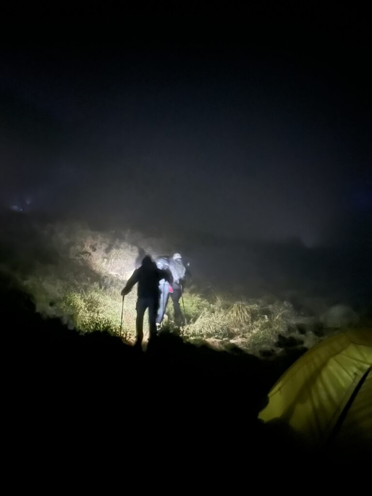
Stage One: Climbing in the Dark
The first section of the summit push begins gently enough.
The trail follows the crater ridge through sparse woodland, where Casuarina trees bend and creak in the wind. The ground here is mostly compact dirt and rock, which feels mercifully stable underfoot compared to what lies ahead.
For the first hour, the climb feels manageable.
The path is narrow but clear, illuminated only by a slow procession of headlamps stretching up the mountainside like a glowing trail of fireflies.
The only sounds are boots crunching on gravel, the occasional cough in the cold air, and the rhythmic slap of our guide’s flip-flops, somehow keeping perfect pace in front of us.
At first, the climb almost feels peaceful.
But gradually the incline begins to bite.
The forest thins out, the wind strengthens, and the temperature drops sharply. What began as a steady walk quickly turns into a full-body effort.
Within two hours, we were sweating heavily despite the cold.
Hiking Mount Rinjani has a funny way of doing that to you.
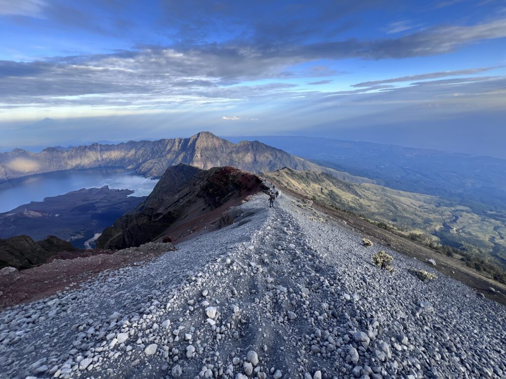
Stage Two: Exposed Volcanic Ridge
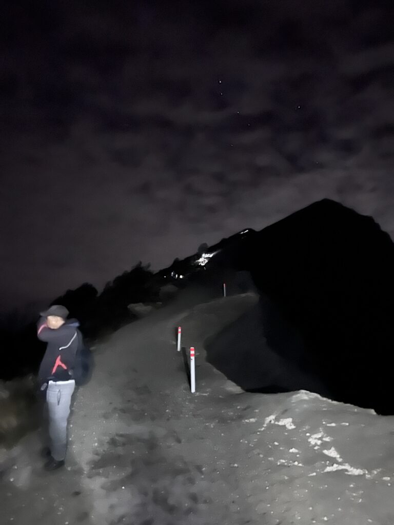
Eventually, the trees disappear completely.
The terrain suddenly opens into a wide expanse of volcanic sand, loose gravel, and boulders, and the wind becomes brutally cold. Without the shelter of the forest, the chill cuts straight through damp, sweat-soaked clothing.
The sweat from the earlier climb now works against you.
Stop moving for more than a few minutes, and the cold begins creeping into your bones.
This section of hiking Mount Rinjani feels strangely surreal.
It’s still pitch black, and your headlamp only illuminates a few metres ahead. Beyond that, the mountain disappears into darkness. Somewhere on either side of the trail are steep drops hundreds of metres down the slopes of the volcano, but thankfully, you can’t see them yet.
And that’s probably for the best.
The higher we climbed, the more the summit dominates your thoughts. Every few minutes, someone would ask the guide the same question:
“How much further?”
The answer was always the same.
“Almost there.”
Which, as it turns out, is an extremely flexible concept on a volcano.
Still, there’s something magical about the shared suffering of a mountain climb. Every so often, a stranger would pass by and offer a few encouraging words.
“You’re nearly there.”
“We’ve got this.”
It’s incredible how motivating unsolicited encouragement from strangers can be when you’re halfway up a volcano at four in the morning.
Stage Three: “Two Steps Forward, One Step Back”
The final section of hiking Mount Rinjani’s summit is infamous.
Locals describe it as “two steps forward, one step back.”
That description is painfully accurate.
The last 500 metres of elevation are essentially a steep slope of loose volcanic gravel and sand. Every step sinks into the ground, sliding slightly backwards as the surface shifts beneath your boots.
Progress slows dramatically.
You can see the summit ridge above you, but it somehow never seems to get closer.
Every step feels like climbing an escalator that’s trying to drag you backwards.
Breaks that once came every twenty minutes now happen every five. My legs were screaming, my lower back was on strike, and my vocabulary for insulting loose rocks expanded dramatically.
This is where the real test of hiking Mount Rinjani happens — not just physically, but mentally.
You just keep moving.
Step.
Slide.
Step.
Slide.
Repeat.
Eventually, the sky began to lighten slightly, revealing the faint outline of the horizon.
Separated only by a few hundred meters and a sadistically steep gravel slope.
Sunrise on the Summit of Mount Rinjani
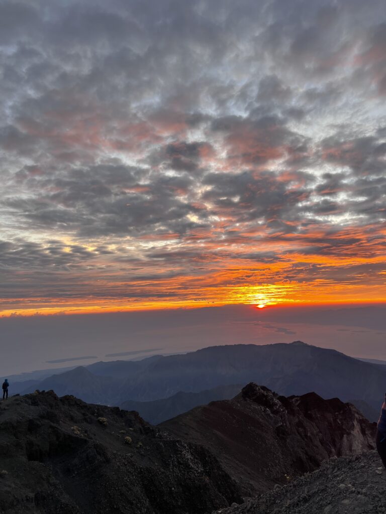
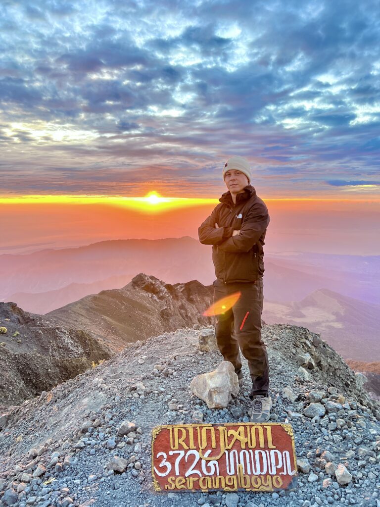
We reached the summit just before 6:00am.
And then, almost on cue, the sun appeared.
The first rays of sunlight burst over the horizon, spilling golden-red light across Lombok, Bali, and the surrounding islands. Clouds drifted across the landscape far below, turning the entire scene into something that looked almost unreal.
For a few minutes, nobody spoke.
All the exhaustion, the cold, the frustration of the climb, evaporated instantly.
Standing on the summit after hiking Mount Rinjani through the night was one of those rare travel moments where the effort and the reward align perfectly.
The summit itself is exposed, windy, and surprisingly crowded with hikers celebrating their own victories. But none of that really matters.
What matters is that we had made it.
Against the odds, against the exhaustion, against every moment of self-doubt.
We had made it.
Back to the Crater Rim – 1.1 KM
Summit of Mount Rinjani (3,726m) → Sembalun Crater Rim (2,639m)
After about an hour on the summit, reality slowly returned, and that reality involved descending the entire volcano.
Thankfully, the descent to the crater rim is far quicker than the climb, especially if you take advantage of a technique called scree running.
A group of wildly enthusiastic German and Swedish hikers showed me how it works.
Instead of cautiously stepping down the loose volcanic gravel, you lean slightly back, plant your trekking poles, and essentially run down the slope like you’re skiing on sand.
It’s equal parts terrifying and exhilarating.
Within minutes, I was bouncing down the scree fields, half running, half sliding, grinning like an idiot as the descent that took hours to climb suddenly became ridiculously fun.
The rising sun revealed the full scale of the landscape around us — towering ridges, dramatic volcanic slopes, and sheer drops that were mercifully invisible during the night climb.
In daylight, the mountain looked even more impressive.
And slightly more dangerous.
(For the record: scree running down a 3,900m volcano with 1,000m drop-offs is not officially recommended unless you enjoy a healthy dose of adrenaline.)
The Final Descent – The Long Way Down
Within about three hours, we were back at the crater rim campsite.
After a 1 – 2 hour rest and a seemingly inexhaustible supply of banana pancakes for breakfast, the porters had packed up our gear, and we began the long descent back to Sembalun village.
The hike down follows the same route as the climb up, which means another 7–8 hours of trekking back through forest, savannah, and the now very familiar POS checkpoints.
We stopped for lunch again at POS 2; however, this time, for a fee, trail-weary hikers could pay for a motorbike taxi to take them to the entrance gate.
By the time we reached the trailhead around 11:30 am, my legs were finished.
But the feeling that remained wasn’t exhaustion.
It was pride.
Because hiking Mount Rinjani isn’t easy.
It’s tough, unpredictable, occasionally miserable, and absolutely unforgettable.
And standing on that summit at sunrise makes every single step worth it.
Final Thoughts on Hiking Mount Rinjani
So there it is, my full story of hiking Mount Rinjani, Lombok’s giant volcanic leg-destroyer.
Was it glamorous? Not exactly. Between the midnight alarms, the endless uphill slog, and the loose volcanic sand that seems designed purely to ruin your morale, there were definitely moments where I wondered why humans voluntarily climb active volcanoes.
But then the summit happens.
The exhaustion fades, the sky lights up over Lombok, and you realise you’ve just climbed one of the most spectacular volcanoes in Southeast Asia.
Would I do it again tomorrow? Absolutely not.
Am I incredibly proud that I did it? 100%, without a doubt.
If you’re the kind of person who enjoys a challenge and occasionally likes to suffer for a spectacular sunrise, hiking Mount Rinjani might just be your kind of adventure. But if you’re looking for a smaller, yet similarly epic adventure, pr
Planning a wider Indonesia itinerary? Did you know Indonesia is home to real-life dragons? If that sounds like your kind of adventure, don’t miss my guide on how to see Komodo dragons in the wild for everything you need to know about spotting them in their natural habitat.